File:CongoLualaba watershed topo.png
Size of this preview: ༧༢༡ × ༥༩༩ pixels. Other resolutions: ༢༨༩ × ༢༤༠ pixels | ༥༧༨ × ༤༨༠ pixels | ༩༢༤ × ༧༦༨ pixels | ༡,༡༥༠ × ༩༥༦ pixels.
ཐོག་མའི་ཡིག་ཆ། (༡,༡༥༠ × ༩༥༦ བརྙན་རྒྱུ།, ཡིག་ཆ་ཆེ་ཆུང།: ༧༦༨ KB, རྣམ་གཞག།: image/png)
བསྡུས་དོན།
| Description |
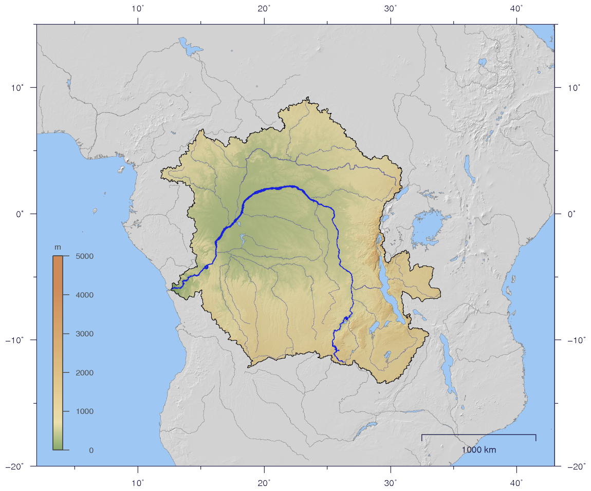
English: Course and Watershed of the Congo and Lualaba River with topography shading.
Deutsch: Verlauf und Einzugsgebiet von Kongo und Lualaba mit Reliefschattierung. |
| Date | |
| Source | The map has been created with the Generic Mapping Tools: http://gmt.soest.hawaii.edu/ using additional public comain data from the VMAP0 data set. |
| Author | Imagico |
| Permission (Reusing this file) |
This file is licensed under the Creative Commons Attribution-Share Alike 2.5 Generic license.
|
| Other versions |
Derivative works of this file: Aruwimi-Ituri.png Image:CongoLualaba_watershed_plain.png |
གན་རྒྱ་ནང་ཞུགས་པ།
I, the copyright holder of this work, hereby publish it under the following license:
This file is licensed under the Creative Commons Attribution-Share Alike 2.5 Generic license.
- You are free:
- to share – to copy, distribute and transmit the work
- to remix – to adapt the work
- Under the following conditions:
- attribution – You must give appropriate credit, provide a link to the license, and indicate if changes were made. You may do so in any reasonable manner, but not in any way that suggests the licensor endorses you or your use.
- share alike – If you remix, transform, or build upon the material, you must distribute your contributions under the same or compatible license as the original.
ཡིག་ཆའི་ལོ་རྒྱུས།
ཟླ་ཚེས་/དུས་ཚོད་གནུན་ཏེ་རྩོམ་ཡིག་ལ་ལྟ་བ།
| ཚེས་གྲངས། / དུས་ཚོད། | བསྡུས་དོན། | ཚད། | སྤྱོད་མི། | བསམ་ཚུལ། | |
|---|---|---|---|---|---|
| ད་ལྟ། | ༡༩:༥༩, ༢ ཟླ་དང་པོ། ༢༠༠༧ | | ༡,༡༥༠ × ༩༥༦ (༧༦༨ KB) | Imagico | {{Information |Description= {{en|Course and Watershed of the Congo and Lualaba River with topography shading.}} {{de|Verlauf und Einzugsgebiet von Kongo und Lualaba mit Reliefschattierung.}} |Source=The map has been created with the [[:en:Generic Mapping |
ཡིག་ཆ་བེད་སྤྱོད་ཁུལ།
pagelinks འདི་ལ་སྦྲེལ་ཡོད།
Global file usage
The following other wikis use this file:
- Usage on af.wikipedia.org
- Usage on als.wikipedia.org
- Usage on ar.wikipedia.org
- Usage on arz.wikipedia.org
- Usage on as.wikipedia.org
- Usage on az.wikipedia.org
- Usage on ba.wikipedia.org
- Usage on be.wikipedia.org
- Usage on bg.wikipedia.org
- Usage on bn.wikipedia.org
- Usage on br.wikipedia.org
- Usage on ca.wikipedia.org
- Usage on ceb.wikipedia.org
- Usage on ckb.wikipedia.org
- Usage on cs.wikipedia.org
- Usage on da.wikipedia.org
- Usage on de.wikipedia.org
- Usage on dsb.wikipedia.org
- Usage on en.wikipedia.org
- Usage on en.wiktionary.org
- Usage on eo.wikipedia.org
- Usage on es.wikipedia.org
- Usage on et.wikipedia.org
- Usage on fi.wikipedia.org
- Usage on fo.wikipedia.org
- Usage on frr.wikipedia.org
- Usage on fr.wikipedia.org
View more global usage of this file.