File:Lake Whitney & Whitney Dam.jpg

Size of this preview: ༨༠༠ × ༥༣༣ pixels. Other resolutions: ༣༢༠ × ༢༡༣ pixels | ༦༤༠ × ༤༢༧ pixels | ༡,༠༢༤ × ༦༨༣ pixels | ༡,༥༠༠ × ༡,༠༠༠ pixels.
ཐོག་མའི་ཡིག་ཆ། (༡,༥༠༠ × ༡,༠༠༠ བརྙན་རྒྱུ།, ཡིག་ཆ་ཆེ་ཆུང།: ༢༣༤ KB, རྣམ་གཞག།: image/jpeg)
| Description |
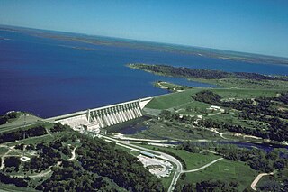
English: Aerial view of Whitney Lake and Dam on the Brazos River in Bosque and Hill Counties, Texas, USA. The river and lake form part of the border between the two counties. The U.S. Army Corps of Engineers constructed the dam in 1951 for flood control and water supply. View is to the north.
Coordinates: 31°51′59.45″N 97°22′15.64″W / 31.8665139°N 97.3710111°W |
|||
| Location | Bosque and Hill Counties, Texas, USA | |||
| Date | not specified or unknown | |||
| Source |
U.S. Army Corps of Engineers Digital Visual Library Image page Image description page Digital Visual Library home page |
|||
| Author | U.S. Army Corps of Engineers, photographer not specified or unknown | |||
| Permission (Reusing this file) |
|
ཡིག་ཆའི་ལོ་རྒྱུས།
ཟླ་ཚེས་/དུས་ཚོད་གནུན་ཏེ་རྩོམ་ཡིག་ལ་ལྟ་བ།
| ཚེས་གྲངས། / དུས་ཚོད། | བསྡུས་དོན། | ཚད། | སྤྱོད་མི། | བསམ་ཚུལ། | |
|---|---|---|---|---|---|
| ད་ལྟ། | ༠༡:༣༩, ༡༩ ཟླ་ལྔ་བ། ༢༠༠༧ | | ༡,༥༠༠ × ༡,༠༠༠ (༢༣༤ KB) | DanMS | {{Information | Description = {{en|Aerial view of Whitney Lake and Dam on the Brazos River in Bosque and Hill Counties, Texas, USA. The river and lake form part of the border between the two counties. The U.S. Army Corps of Engineers constructed the da |
ཡིག་ཆ་བེད་སྤྱོད་ཁུལ།
pagelinks འདི་ལ་སྦྲེལ་ཡོད།
Global file usage
The following other wikis use this file:
- Usage on ceb.wikipedia.org
- Usage on da.wikipedia.org
- Usage on de.wikipedia.org
- Usage on en.wikipedia.org
- Usage on es.wikipedia.org
- Usage on fa.wikipedia.org
- Usage on fr.wikipedia.org
- Usage on ja.wikipedia.org
- Usage on no.wikipedia.org
- Usage on sv.wikipedia.org
- Usage on www.wikidata.org