File:Wisconsin in 1718.jpg
No higher resolution available.
Wisconsin_in_1718.jpg (༦༤༠ × ༤༨༠ བརྙན་རྒྱུ།, ཡིག་ཆ་ཆེ་ཆུང།: ༡༨༤ KB, རྣམ་གཞག།: image/jpeg)
བསྡུས་དོན།
| Description |
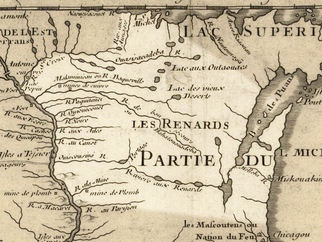
English: Wisconsin 1718, approximate modern state area highlighted, from Carte de la Louisiane et du cours du Mississipi by Guillaume de L'Isle. |
|||||||||||||||||||||||
| Date | (mod. 2009) | |||||||||||||||||||||||
| Source | Library of Congress Public Domain Site: http://hdl.loc.gov/loc.gmd/g3700.ct000666 | |||||||||||||||||||||||
| Author |
|
|||||||||||||||||||||||
| Permission (Reusing this file) |
US Govt Public Domain, also author +100 years | |||||||||||||||||||||||

གན་རྒྱ་ནང་ཞུགས་པ།
|
This work is in the public domain in its country of origin and other countries and areas where the copyright term is the author's life plus 100 years or fewer. | |
| This file has been identified as being free of known restrictions under copyright law, including all related and neighboring rights. | |
Original upload log
The original description page was here. All following user names refer to en.wikipedia.
- 2009-07-24 20:14 Billwhittaker 640×480× (188239 bytes) {{Information |Description = Wisconsin 1718, approximate modern state area highlighted, from Carte de la Louisiane et du cours du Mississipi by Guillaume de L'Isle. |Source = Library of Congress Public Domain Site: http://hdl.loc.gov/loc.gmd
ཡིག་ཆའི་ལོ་རྒྱུས།
ཟླ་ཚེས་/དུས་ཚོད་གནུན་ཏེ་རྩོམ་ཡིག་ལ་ལྟ་བ།
| ཚེས་གྲངས། / དུས་ཚོད། | བསྡུས་དོན། | ཚད། | སྤྱོད་མི། | བསམ་ཚུལ། | |
|---|---|---|---|---|---|
| ད་ལྟ། | ༡༩:༣༧, ༢༡ ཟླ་དགུ་བ། ༢༠༠༩ | | ༦༤༠ × ༤༨༠ (༡༨༤ KB) | Jeangagnon | {{Information |Description={{en|Wisconsin 1718, approximate modern state area highlighted, from ''Carte de la Louisiane et du cours du Mississipi'' by en:Guillaume de L'Isle.}} |Source=Transferred from [http://en.wikipedia.org en.wikipedia]<br/> (Or |
ཡིག་ཆ་བེད་སྤྱོད་ཁུལ།
pagelinks འདི་ལ་སྦྲེལ་ཡོད།
Global file usage
The following other wikis use this file:
- Usage on arz.wikipedia.org
- Usage on azb.wikipedia.org
- Usage on ceb.wikipedia.org
- Usage on cs.wikipedia.org
- Usage on de.wikipedia.org
- Usage on en.wikipedia.org
- Usage on es.wikipedia.org
- Usage on et.wikipedia.org
- Usage on fr.wikipedia.org
- Usage on hr.wiktionary.org
- Usage on hsb.wikipedia.org
- Usage on hy.wikipedia.org
- Usage on it.wikipedia.org
- Usage on ja.wikipedia.org
- Usage on kn.wikipedia.org
- Usage on ko.wikipedia.org
- Usage on ml.wikipedia.org
- Usage on pt.wikipedia.org
- Usage on simple.wikipedia.org
- Usage on te.wikipedia.org