File:Zhs South Sudan-administrative map.png

Size of this preview: ༨༠༠ × ༥༣༦ pixels. Other resolutions: ༣༢༠ × ༢༡༥ pixels | ༦༤༠ × ༤༢༩ pixels | ༡,༠༢༤ × ༦༨༧ pixels | ༡,༢༨༠ × ༨༥༨ pixels | ༢,༣༠༠ × ༡,༥༤༢ pixels.
ཐོག་མའི་ཡིག་ཆ། (༢,༣༠༠ × ༡,༥༤༢ བརྙན་རྒྱུ།, ཡིག་ཆ་ཆེ་ཆུང།: ༡༠༦ KB, རྣམ་གཞག།: image/png)
| Description |
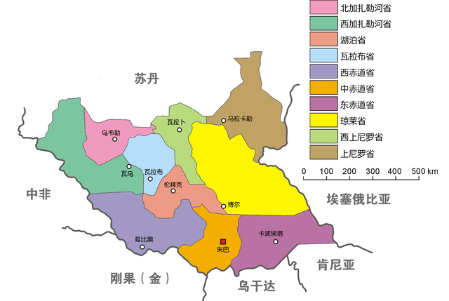
English: Administrative map of South Sudan. Adapted from Polish-language version by Aotearoa. |
| Date | (UTC) |
| Source | |
| Author |
|
| This is a retouched picture, which means that it has been digitally altered from its original version. Modifications: 中文. The original can be viewed here: South Sudan-administrative map.png:
|
I, the copyright holder of this work, hereby publish it under the following license:
| This file is made available under the Creative Commons CC0 1.0 Universal Public Domain Dedication. | |
| The person who associated a work with this deed has dedicated the work to the public domain by waiving all of their rights to the work worldwide under copyright law, including all related and neighboring rights, to the extent allowed by law. You can copy, modify, distribute and perform the work, even for commercial purposes, all without asking permission.
|
Original upload log
This image is a derivative work of the following images:
- File:South_Sudan-administrative_map.png licensed with Cc-zero
- 2011-07-08T11:54:08Z Kudzu1 2300x1542 (170857 Bytes) Corrects preferred anglicization of Bahr el Ghazal.
- 2011-07-08T10:30:28Z Kudzu1 2300x1542 (190800 Bytes) {{Information |Description ={{en|1=Administrative map of South Sudan. Adapted from Polish-language version by [[User:Aotearoa|Aotearoa]].}} |Source ={{own}} |Author =[[User:Kudzu1|Kudzu1]], [[User:Aotearoa|
Uploaded with derivativeFX
ཡིག་ཆའི་ལོ་རྒྱུས།
ཟླ་ཚེས་/དུས་ཚོད་གནུན་ཏེ་རྩོམ་ཡིག་ལ་ལྟ་བ།
| ཚེས་གྲངས། / དུས་ཚོད། | བསྡུས་དོན། | ཚད། | སྤྱོད་མི། | བསམ་ཚུལ། | |
|---|---|---|---|---|---|
| ད་ལྟ། | ༠༡:༤༩, ༡༡ ཟླ་བདུན་པ། ༢༠༡༡ | | ༢,༣༠༠ × ༡,༥༤༢ (༡༠༦ KB) | 玖巧仔 | {{Information |Description={{en|1=Administrative map of South Sudan. Adapted from Polish-language version by Aotearoa.}} |Source=*File:South_Sudan-administrative_map.png |Date=2011-07-11 01:48 (UTC) |Author=*[[:File:South_Sudan-adm |
ཡིག་ཆ་བེད་སྤྱོད་ཁུལ།
pagelinks འདི་ལ་སྦྲེལ་ཡོད།
Global file usage
The following other wikis use this file:
- Usage on zh.wikipedia.org